Activity maps
More information
-
 1:25,000 ACTIVITY SET FLAT
Collection of five 1:25,000 scale paper Activity Maps consisting of the Glens of Antrim, Mournes, Strangford Lough, Lough Erne, Causeway Coast and Rathlin Island - printed on water resistant paper - includes tracks, cliffs, climbs etc. (flat product)
- Price
- £35.40 (This product is VAT exempt. Price excludes postage)
-
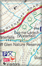
CAUSEWAY COAST AND RATHLIN ISLAND ACTIVITY MAP FLAT
The Causeway Coast and Rathlin Island Activity map - printed on water-resistant paper - provides a detailed guide to the north coast scenic route, including the Giants Causeway World Heritage site and North West 200 road race. (flat product). Published 2016.
- Price
- £10.60 (This product is VAT exempt. Price excludes postage)
-
CAUSEWAY COAST AND RATHLIN ISLAND ACTIVITY MAP FOLDED
The Causeway Coast and Rathlin Island Activity map - printed on water-resistant paper - provides a detailed guide to the north coast scenic route, including the Giants Causeway World Heritage site and North West 200 road race. (folded product). Published 2016.
- Price
- £10.60 (This product is VAT exempt. Price excludes postage)
-
GLENS OF ANTRIM ACTIVITY MAP FLAT
The Glens Of Antrim Activity Map - printed on water-resistant paper - includes tracks, walks, scenic routes - includes Glens uplands area (flat product). Published 2012.
- Price
- £10.60 (This product is VAT exempt. Price excludes postage)
-
GLENS OF ANTRIM ACTIVITY MAP FOLDED
The Glens of Antrim Activity map - printed on water-resistant paper - includes tracks, walks, scenic routes - includes Glens uplands area (folded product). Published 2012.
- Price
- £10.60 (This product is VAT exempt. Price excludes postage)
-
LOUGH ERNE ACTIVITY MAP FLAT
Lough Erne Activity Map, including navigation markers for the waterways, as well as detailed contours and trails (flat product). Published 2008.
- Price
- £10.60 (This product is VAT exempt. Price excludes postage)
-
LOUGH ERNE ACTIVITY MAP FOLDED
Lough Erne Activity Map, including navigation markers for the waterways, as well as detailed contours and trails (folded product). Published 2008.
- Price
- £10.60 (This product is VAT exempt. Price excludes postage)
-
MOURNES ACTIVITY MAP FLAT
The Mournes Activity Map - printed on water resistant paper - includes tracks, cliffs, climbs etc. (flat product). Published 2019.
- Price
- £10.60 (This product is VAT exempt. Price excludes postage)
-
MOURNES ACTIVITY MAP FOLDED
The Mournes Activity Map - printed on water resistant paper - includes tracks, cliffs, climbs etc. (folded product). Published 2019.
- Price
- £10.60 (This product is VAT exempt. Price excludes postage)
-
STRANGFORD LOUGH ACTIVITY MAP FLAT
Strangford Lough Activity Map, including detail for parks and National Trust properties, as well as the many islands in the lough (flat product). Published 2008.
- Price
- £10.60 (This product is VAT exempt. Price excludes postage)
-
STRANGFORD LOUGH ACTIVITY MAP FOLDED
Strangford Lough Activity Map, including detail for parks and National Trust properties, as well as the many islands in the lough (folded product). Published 2008.
- Price
- £10.60 (This product is VAT exempt. Price excludes postage)
This item is currently out of stock