Address data and gazetteers
Pointer data
Pointer is widely recognized as the definitive spatial address dataset for Northern Ireland. Each property has a unique property reference number (UPRN) and address and building status. Data includes the full product, updated each day, along with updates-only files. Available in csv format. Postal Address File (PAF) usage return form to be completed upon licensing.
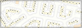
1:50,000 gazetteer
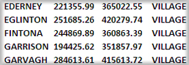
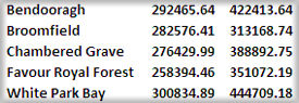
Textual gazetteer based on 1:50,000 mapping containing place names and points of interest. Provided in txt format.
1:250,000 gazetteer
Textual gazetteer based on 1:250,000 mapping containing place names and points of interest. Available in txt format.
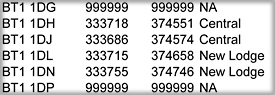
Central Postcode Directory
Database containing postcodes in Northern Ireland with associated Irish Grid co-ordinates and associated administrative boundaries and NISRA geographies. Available in Access Database (.mdb) format. Download contains Postal Address File (PAF) usage return form to be completed upon licensing.

LPS Property Data
The Land & Property Services (LPS) Property Data products contain all properties in the domestic and non-domestic valuation lists. Data is provided as a comma separated (csv) text file with full Northern Ireland coverage. Updates-only files are not available.